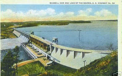
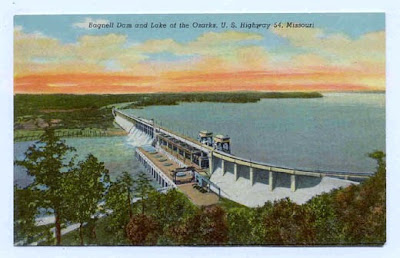
Bagnell Dam was completed and the Lake of the Ozarks began to fill February 1931, which was during the Linen Card Era of postal cards. With The Great Osage River Project having been recognized as one of the greatest engineering and construction feats of its time it was a popular subject for the advanced technology that allowed publishers to print cards on a linen type paper stock with very bright and vivid colors. Bagnell Dam continued to be a popular subject as postal cards advanced into the Modern Photochrome Era. Many shops and tourist attractions along the Bagnell Dam Strip continue to offer postcards today, 77 years after the dams completion.

Back of this card: Erected in 1929-1931 by Stone and Webster Engineering Corp., Boston, Mass. And owned by Union Electric Light & Power Co., of St. Louis, MO. Built across Osage River in Missouri. The lake formed by Bagnell Dam is 129 miles long, has a shoreline of 1300 miles and covers an area of 95 sq. miles

Back of this card: A fifty-foot cut through solid rock marks the northern approach to Bagnell Dam. Located about 40 miles south of Jefferson City, Capitol of Missouri, Bagnell Dam forms beautiful Lake of the Ozarks.

Back of this card: BAGNELL DAM AT LAKESIDE, is a hydro-electric power plant in the Union electric Light and Power Company's System which serves the St. Louis District and a large part of the Central Mississippi Valley. Present installed capacity 129,000 kilowatts. The dam is half-a-mile long and 148 feet high. The Lake of the Ozarks, created by the building of the dam, is one of the world's largest wholly artificial bodies of water. the scenic shoreline of 1,300 miles extends through six counties. This is the new Middle-West mecca for tourists and vacationists.

Back of this card: BAGNELL DAM, built in 1931, across the Osage River, is 2,543 feet long, 148 feet high from bedrock, and carries U.S. Highway 54. The dam created the great Lake of the Ozarks---130 miles long and the tremendous shoreline of 1,372 miles---covering an area of 95 sq. miles. This beautiful lake is visited by thousands yearly, who spend their vacations in the many large resorts in the area.

Back of this card: Approach to Bagnell Dam, which towers 148 feet above bedrock, is 2543 feet in length. The water impounded by this dam is approximately 650,000,000 gallons.

Back of this card: In the blue hills of the Ozarks, in a primitive setting amid woodlands and rugged cliffs, is the beautiful Lake of the Ozarks; area 95 square miles; an irregular shoreline of 1,300 miles with unparalleled scenic grandeur, picturesque coves and inlets to be explored; width one to five miles; hydro-electric capacity, 268,000 horsepower; U. S. Highway 54 crosses over the top of the dam, which towers 148 feet from bedrock. Behind it could be hidden a row of twelve-story buildings seven city blocks long. The impounded water could supply the daily needs of St. Louis for over twelve years.

Back of this card: Bagnell Dam which impounds the waters of the Osage River at Lake Ozark, Mo., to form the 1,372 mile shore line of the Lake of the Ozarks in Central Missouri. U. S. Highway 54 crosses over the dam, which is over half a mile long and high enough to hide from view a series of twelve-story buildings. The Lake of the Ozarks region includes literally hundreds of resorts and cabin courts for the traveler.

Back of this card: Erected across the Osage river, Bagnell Dam formed beautiful Lake of The Ozarks. This Lake is 129 miles long, has approximately 1300 miles of shore line, covers 60,000 acres and contains 97,000,000 cubic feet of water. The dam is 2,543 ft. long and 148 ft. high. This great lake offers the finest of tourist accommodations, fishing, boating, and other recreational activities. It has become one of the nation's greatest playgrounds.


